
NAVADWIP: THE ‘NEW ISLAND’ HYPOTHESIS
By Jeevanmukta Das
Earlier I had written an article titled ‘Navadwip Notes’ in which I discussed the geographical reconstruction of Sridham Navadwip. I now have additional information on the subject and wish to present it here along with the material I had presented earlier.
As mentioned in my earlier article, I am an amateur landscape archaeologist of sorts, and have recently published a book identifying the real temple of Jerusalem, the one that Solomon built, in the mountains of Modern-day Syria. (Read my book, ‘The Bible Betrayed.’ http://www.thebiblebetrayed.com).
Being a devotee, I decided to apply my so-called expertise in unraveling the mystery concerning Navadwip Dham. One day, while lazily scanning the Dham with Google Earth, I noticed a clear island formation west of the Ganges opposite the current birth-place site. Zooming out a bit I was shocked to find that the whole area was terribly scarred by the virulently oscillating river. Trapped bit of river loops or oxbow lakes were everywhere. I could identify about a dozen or so of such lakes. (Use Google Earth to inspect Navadwip)
Let me explain. At times, when the soil is very sandy or loose, a river tends to undulate into tight loops. Over time, some of these loops break off and gets hemmed in by land when the river short-circuits the loops and eventually migrates away. This action eventually creates the classical formation called ‘oxbow lake’ for it shape is similar to the inverted ‘u’ shaped European yoke used to harness an ox to the plough.
Now, there is a stage that may be said to be one step before the oxbow lake formation. This is when the river has short-circuits the loop but has yet to migrate away. The formation that distinctly stands out at this stage is that of an island trapped within the loop and the river new bed.
The short-circuiting of the loop is a relatively fast development and can literally happen overnight. I mean, you can actually wake one morning to the cries of “dada, the river has broken though; we are now living on an island!” Such being the case, it is quite conceivable that the newly formed island would be dubbed ‘new island’ for want of an immediately available consensus name. In Bengali that would of course be… ‘Navadwip.’ ‘Nava’ means ‘new’ and ‘dwip’ means ‘island.’ Incidentally, ‘oxbow lakes’ and such newly formed ‘river islands’ are seen the world over where ever the river tends to tightly loop.
Now I know very well the ‘nava’ means ‘nine’ and ‘the nine processes of bhakti yoga represented by each of the island’ theology that goes with it. This ideology was first proposed by Narahari and the same was later adopted by Bhakti Vinod Thakur. Unfortunately, a cluster of nine islands, while not improbable, would be difficult to accommodate in this tight region. There is no mention of nine islands in the biographies of Mahaprabhu either. Furthermore, somehow the landscape with its innumerable ‘oxbow lake’ and ‘new island’ formation (see earlier picture) the more accurate rendering of the term ‘Navadwip’ would be ‘new island’ rather than the theologically inspired ‘nine island’ name tag. The ‘new island’ interpretation (although not the formation dynamics that I have elaborated here) is also held by Muslim scholars of nearby Bangladesh.
The first temple built to mark Mahaprabhu’s birthplace was commissioned by Bir Hambir of Vishnupur, who ruled from approximately 1586-1621. This small shrine was claimed by the Ganges. Later, Gaur Govinda Singh, the Diwan of the East India Company under Warren Hastings, built a second temple on the same site in 1780. This sixty foot high building with nine pinnacles in red sandstone too was washed away in floods in 1876.
In 1891, Srila Bhakti Vinod Thakur, after much research, identified a new site as the real birthplace of Mahaprabhu on Anterdwip. This one lies between the Ganges and Jalangi. He called it Sridham Mayapur. Why Mayapur? I do not know, but possibly Mayapur represents the centre of the nine-island theological reconstruction of the Dham. Naturally, the Chaitanya Charitamrita and Chaitanya Bhagavat, do not mention Mayapur and merely offers the name Nadia or Navadwip. Very likely ‘Nadia’ is the truncated version of the original name Navadwip. People tend to drop extraneous syllables to shorten names, make it easier on the tongue and so on and possibly ‘Na-va-di-wi-p’ eventually gave birth to ‘Na-di-a.’
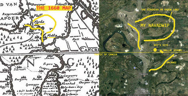
How did Srila Bhakti Vinod Thakur identify Mayapur? Well, the Thakur, it appears, had come across the 1780’s map which Gaur Govinda Singh had produced and or used. Also, he may have used an archaeological ruin mound in the region to triangulate his site. Apart from these mundane pointers, Srila Bhakti Vinod Thakur was guided by a grand vision that indicated this very region.
Unfortunately, I do not have the 1780’s Gaur Govinda Singh map. I do however have a much older map produced by Van der Brouck in 1660. Based on this map, the Ganges flows by the west of Nadia and the river Jalangi apparently forms its eastern border.
Now, I am not quite convinced that the river Jalangi was anywhere close to the core Navadwip area for the simple reason that it is not mentioned anywhere in the biographies of Mahaprabhu. No one is documented to have boated, bathed or got baptized in the Jalangi. Besides, had Jalangi been here, it would eminently have served as the easily identifiable landmark boundary of Nadia and we would have heard statements to the effect that ‘Nadia lies between the River Ganges and Jalangi’ or Nadia was situated at the confluence of the rivers Ganges and Jalangi. What could have been simpler? But no, we do not hear any such thing. Instead, Roop Goswami states in his Stavamala, Vol 4, Navadvipa-Dhamastakam:
sri gauda-dese sura-dirghikayas
tire ‘ti-ramye pura-punya-mayyah
lasantam ananda-bharena nityam
tam sri navadvipam aham smarami
“I mediate on Sri Navadwip that is situated in Sri Gauda Desa by the banks of a heavenly dirghika, and shines with pure eternal bliss.”
Roop Goswami tells us that ‘Navadwip was situated on the banks of a ‘dirghika.’
According to Prof. K. N. Mukerjee, Retired head of the Dept. of Geography, City College, Calcutta, a ‘dirghika’ or ‘dirghi’ (short form) is the generic term for a ‘long water body’ or ‘canal.’ He also states that a ‘dirghi’ played a pivotal role in the identification of Srila Bhakti Vinod Thakur’s Mayapur site.
The fact is, an archaeological ‘Tell’ or mound some 30ft high and spread over 1300 sq ft existed in this region which the locals called by the name ‘Ballal Dhipi.’ Ballal Sen was the king who ruled this region between 1160 and 1178. In 1980, the Archaeological Survey of India (ASI) excavated the Dhipi and found it to contain ruins of an edifice, the nature of which they yet to have determine. (See picture)

Now, to my knowledge, there is no mention of a separate ‘dirghi’ here. Therefore, my guess is the Prof. K. N. Mukerjee got his ‘dirghi’ is by tweaking the term ‘dhipi.’ Archaeologists in general, by the way, are notorious for doing this manner of tweaking and then off they go and anchor some fanciful theory or the other with it! This ‘dhipi tweaked to dirghi’ was conjectured to be the dirghi or dirghika mentioned in the above-mentioned Roop Goswami’s verse, which then would read, ‘Nadia extended from the Ganges to the ‘Ballal Dirghi.’
There is another thing that worries me. As mentioned earlier, the Jalangi is conveniently situated to the east of the currently accepted birth site, and would ideally have served as its eastern boundary. It also happens to be just stone’s throw away from the so-called Ballal Dirghi. So, the question is, why would Roop Goswami have chosen the Ballal dirghi (which is no long there) over Jalangi, a perennial river to mark the boundaries of Nadia? Certainly, Roop Goswami could easily have seen that a more permanent landmark would have been the better choice here than a dirghi however celebrated, for the very practical reason that the dirghi could get obscured in fifty or a hundred years down the road whereas a river is likely to remain almost forever.
Also, the Ballal Dirghi does not offer much in terms of a demarcating boundary. What is needed is a landmark that offers an extended ‘line’ boundary, rather than a ‘point’ on a map. The Ballal Dirghi, even with its purported 1 kilometer length, does not offer a ‘line’ boundary by which to conveniently demarcate Nadia’s eastern boundary. Furthermore, the Ballal Dirghi as depicted in maps, was in fact perpendicular to the Ganges! This further reduces its usefulness as a bounding boundary. In short, the Ballal Dirghi seems contrived and hardly suitable as the eastern boundary of Nadia.
But make no mistake. The Ballal Dirghika was celebrated, had ambrosial, crystal clear water and so on and appears to have been a much appreciated body of water. Even the Muslim scholars parrot these qualities in an unusual show of solidarity. Yet somehow I find it… a bit forced. I mean, I can imagine such a tank being much appreciated in arid Rajasthan… But here, between innumerable tributaries, oxbow lakes and what not, and not to mention the fact that Navadwip goes under eight to ten feet of water like clockwork, who has time for a measly tank however ambrosial its waters?
Yet the fact remains that Roop Goswami does mention a dirghika and not the Jalangi which is merely a few hundred meters away. Given this inexplicable discrepancy one is forced to consider the possibility that Navadwip was perhaps not near the Jalangi and by default, the Ballal dirghi.
Faced with this daunting prospect, we are obliged to reexamine the meaning of the term ‘dirghika.’ What exactly was a ‘dirghika’? Upon reexamining the term ‘dirghika,’ I found that it basically means ‘long,’ as in long ‘e’ instead of short ‘e’ kind of thing and where the difference is often depicted by the use of an arced or curved stroke (or an inverted ‘u’) above alphabet in question. ‘Dirghi’ is also specifically used in various parts of India to denote a long canal. If you combine the two ideologies you could get ‘a long curved canal.’
Remember the oxbow lake formation that I described earlier and how this region was chock-a-bloc with such lakes? Well, an oxbow was most definitely is ‘a long body of water.’ It averaged some 10 odd kilometers in length and eminently qualifies as a ‘Dirghika.’ It is also curved and as such all the more suitable to be indicate by the term ‘Dirghika.’ In short, the term ‘Dirghika’ seems almost the tailor-made Sanskrit equivalent to the English term ‘oxbow lake.’
So the question is, was Roop Goswami Dirghika actually an oxbow lake in the region?
As if in answer to this question, another little bit of the mystery falls neatly into place. I am of course referring to the ‘Navadwip mean a new island formed by an oxbow lake’ ideology I had expounded earlier. If that is so, then we have two classical topographical formations anchoring Navadwip. One is the ‘oxbow lakes’ (Dirghika) and two is the ‘new island’ (Nava dwip) formation. It all irrefutably adds up to the fact that Navadwip was a new island that was formed by an oxbow lake that lay adjacent and west of the River Ganges.
Scanning the map, we see that we do indeed have exactly such a formation. What is more, the oxbow lake in question actually encompasses the Nadia marked in 1660 map! (See map) The map also shows numerous ghats (small ports) along the river. Three or four ghats are mentioned in the biographies of Mahaprabhu so finding it marked on this map is encouraging. I am mentioning this because one could excavate these ghats and use it to triangulate the actual birth-site.
To conclude, Navadwip Dham was exactly where the Thakur say it was. I merely submit that it was perhaps a few hundred yards further to the North-East on roughly the same longitude(see above map). The Ballal Dhipi interpretation that may be said to have created a minor confusion was almost certainly the handiwork of the ‘engineer or archaeologist’ who is known to helped the Thakur process his information.
Staying eternally under the shelter of the loving glances of all the Vaishnavas, I, Jeevanmukta Das, submit these lame arguments for the unlimited pleasure of Srila Bhakti Vinod Thakur.